Sitio: Sudbury, Canadá
Año: 2020
Estatus: Concurso internacional abierto
Equipo: Daniel Daou, Priscila Gonzaga, Abraham Zarazúa, Víctor Pineda, Alejandra Ramos, Jaime Palacios
La cultura y vida social de Sudbury tiene lugar en la convergencia de la geología, el paisaje y la infraestructura. La historia moderna de la ciudad está ligada a su pasado geológico. Sudbury se ubica en el segundo mayor cráter de impacto conocido sobre la Tierra. Este evento cósmico es responsable de la riqueza mineral de la región que fue descubierta cuando el país construía su infraestructura ferroviaria. La fundación de la ciudad está ligada al interés de explotar sus yacimientos minerales. Desde entonces, la actividad humana ha cambiado el paisaje definido por las señales que delatan una economía extractivista.
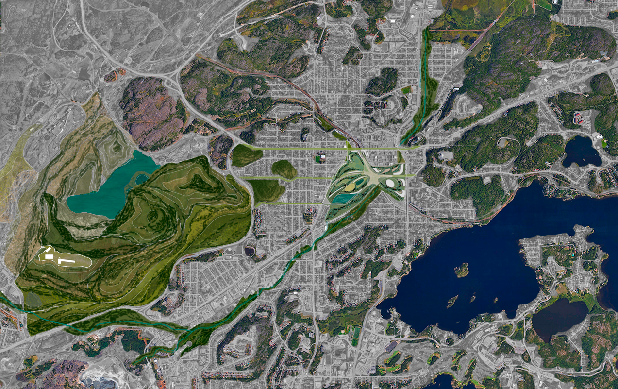
Desde los ochentas, Sudbury ha hecho grandes esfuerzos por diversificar su economía y remediar su entorno–obteniendo reconocimiento internacional por esta labor. Hacia el 2050, la remediación de la mina de Vale podría estar casi concluida. Nuestra propuesta es un eslabón entre las tierras recuperadas en el este y la zona de conservación del lago Minnow en el oeste. Proponemos la recuperación del arroyo de Junction que conecta los otrora sitios de extracción al suroeste con la nueva zona de conservación de Sudbury en el noreste a través de un corredor ripario.
El metabolismo regional incluye el suelo (relaves mineros y biosólidos), agua (drenaje, ríos contaminados con metales pesados y las escorrentías de las cuencas hídricas), vegetación (la producción gestionada de madera y los esfuerzos de reforestación), minerales (niquel y cobre, pero también platino y paladio) y los intercambios atmosféricos (lluvia ácida, gases tóxicos y emisiones producidas por la actividad minera).
En el espacio, Sudbury no puede ser entendida sin una sección que incluya desde la corteza terrestre hasta la estratósfera, y, en el tiempo, desde la era paleoproterozoica hace 1,800 millones de años hasta el Antropoceno. En este contexto, nuestra propuesta completa el centro de un archipiélago de islas verdes–como una araña encaramada al centro de una telaraña esmeralda. El nuevo corazón de Sudbury bombea una transfusión de sangre azul, entretejiendo hebras visuales, históricas y culturales.
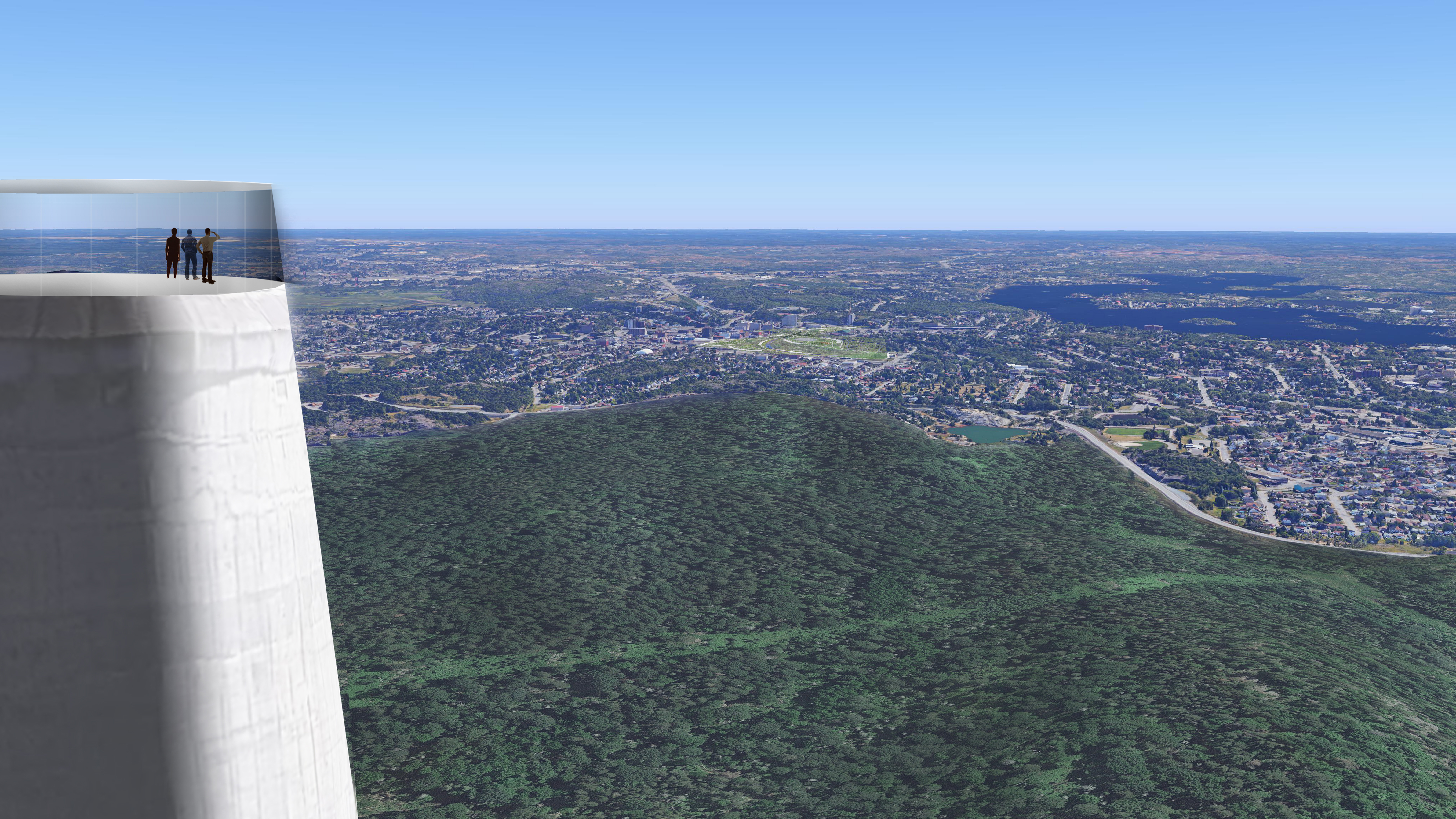
El paisaje infraestructural dejado atrás por la industria minera tiene valor como patrimonio cultural. La llamada “súper chimenea”, con sus 380 metros de altura, es la segunda estructura no habitable más alta de Canadá, y domina el paisaje de la región. Fue construida para dispersar las emisiones de dióxido de carbono más alto en la atmósfera y así evitar los efectos de la lluvia ácida en los alrededores. El año en el que se terminó de construir, 1972, coincide con la celebración de la primera conferencia mundial del entorno humano en Estocolmo, Suecia, misma que marcó el comienzó de la etapa global del movimiento ambiental moderno. Del mismo modo en que la icónica foto de la canica azul, tomada por la NASA también en 1972, cambiara nuestra percepción del entorno planetario, es apropiado que la monumental súper chimenea se convierta en un nueva plataforma de observación pública desde los visitantes puedan adquirir una nueva perspectiva de Sudbury, su nuevo centro, su historia y su paisaje.
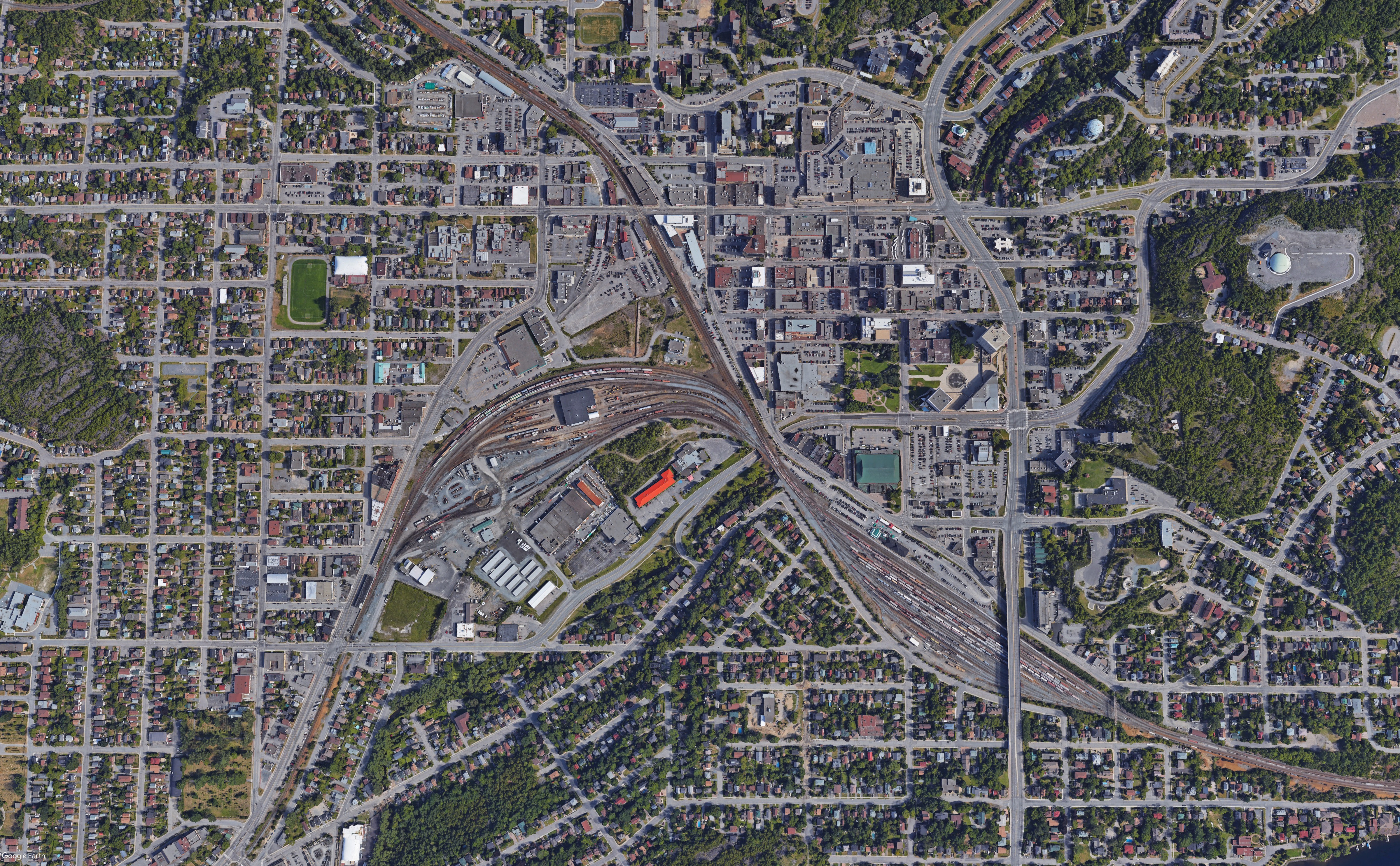
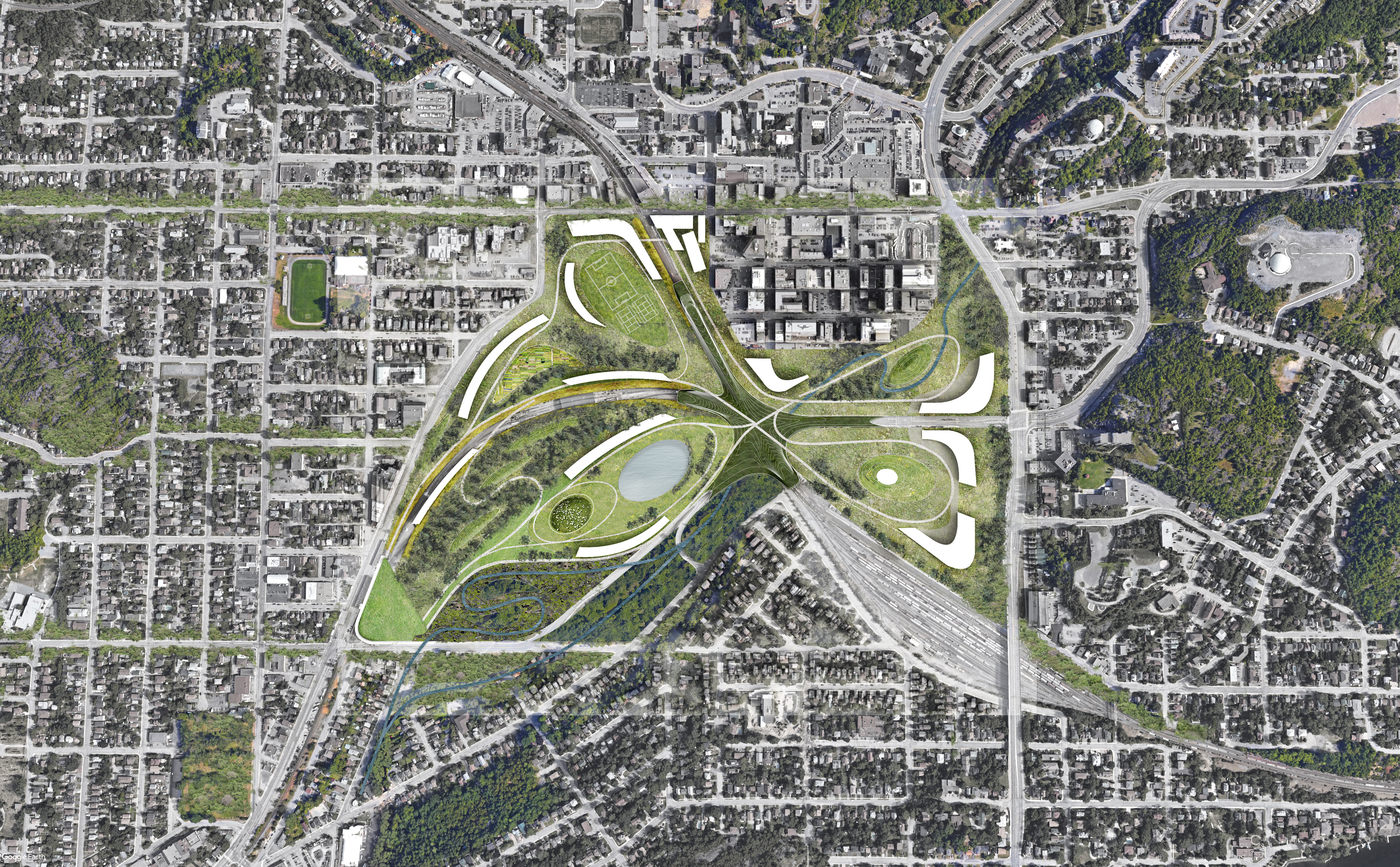
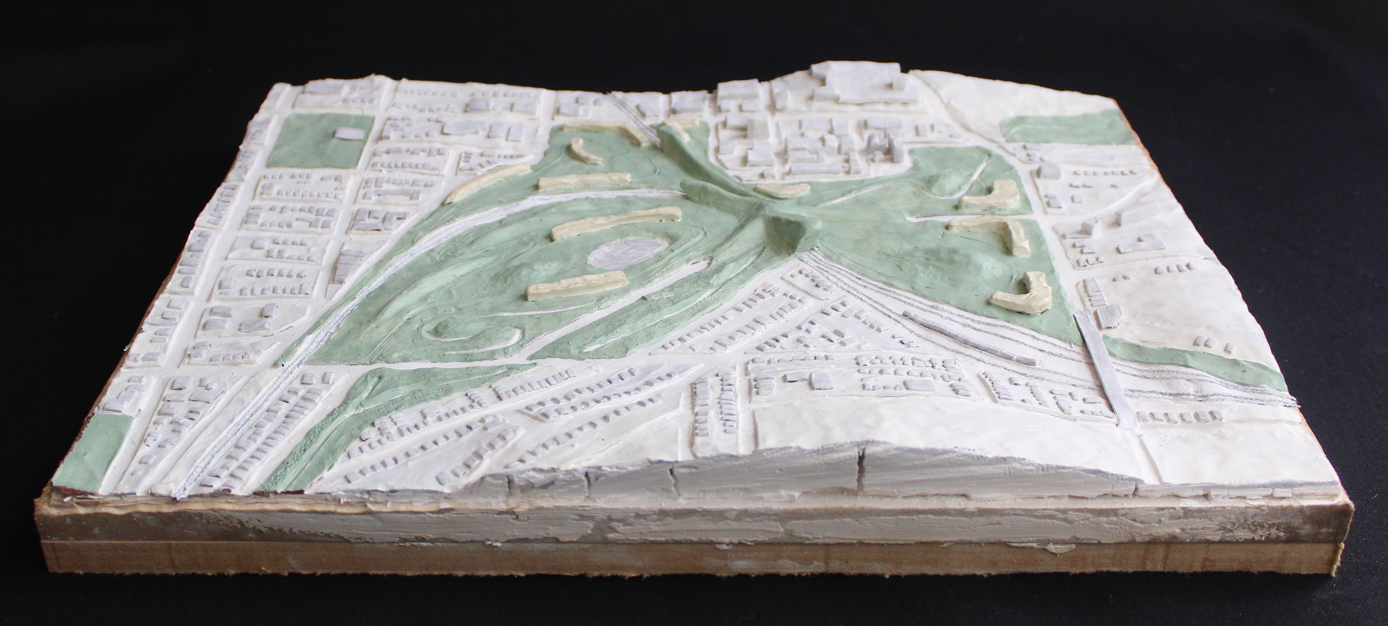
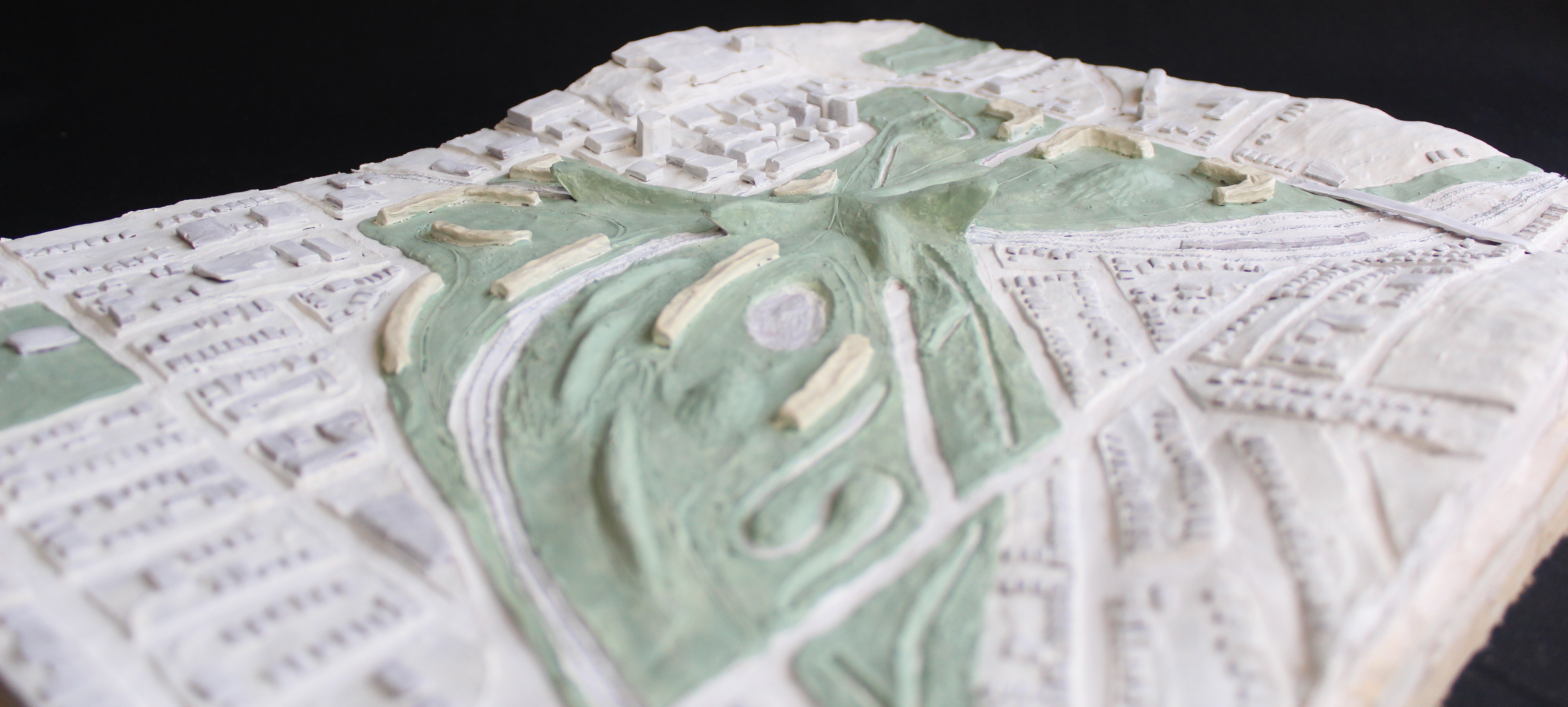
Aspiramos a ilustrar la idea de “una ciudad tan bella como un bosque”. El concepto central de la propuesta es unir los lotes vacíos que rodean las vías del tren y la calle Brady. Una estructura con forma de estrella cubre los tramos de vías de tren que separan estos terrenos vacíos creando una superficie construída contínua de 60 hectáreas que se extiende desde la calle Lorne en el oeste hasta la calle Paris en el este y desde la calle Elm en el norte hasta Riverside drive en el sur. Esta superficie contiene tres “pétalos” o parques temáticos.
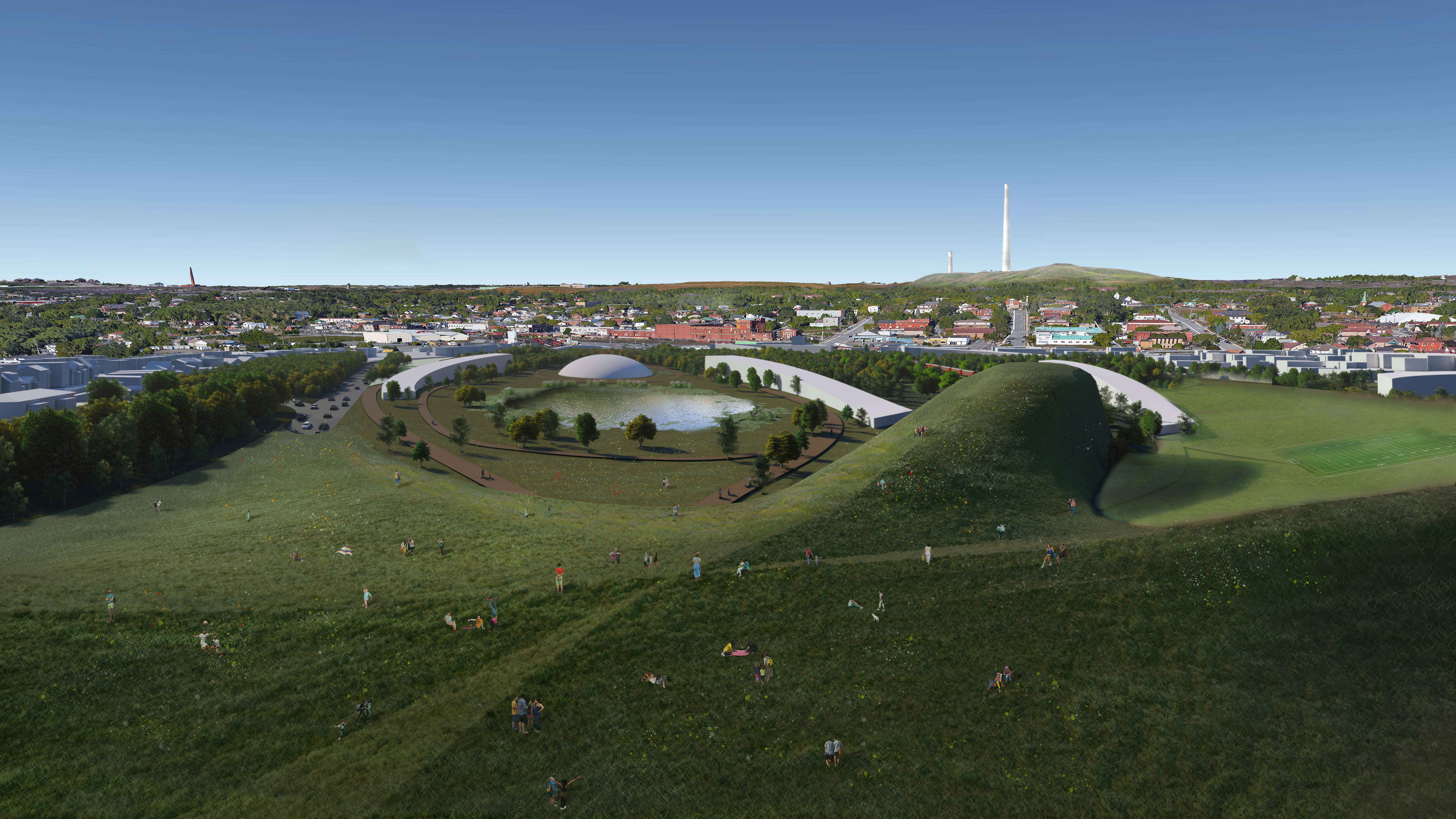
Al sur, un parque ecológico representa un microcosmos de los paisajes que rodean la ciudad. Contiene un bosque urbano, una pradera salvaje, un humedal y el borde ripario del arroyo de Junction. Este pétalo funciona como un paisaje infraestructural que filtra las escorrentías en sus humedales antes de regresarlos al arroyo. También está equipada con un centro para las artes y un escenario al aire libre.
El parque al norte está dedicado a la educación y el esparcimiento. Contiene una extensión para la escuela de arquitectura McEwen, una biblioteca, dormitorios estudiantiles, jardines comunales y campos atléticos. Al oeste, el antiguo centro es revitalizado con un conjunto de equipamientos cívicos clave y todos los estacionamientos son consolidados y convertidos en parques. La mitad sur–The Junction–contiene una arena, un centro de congresos y un hotel. La mitad norte, contiene el palacio de las artes (conectado a la escuela de arquitectura a través de un parque lineal), un City Hall renovado y un Memorial Park ampliado y ahora atravesado por el arroyo de Junction.
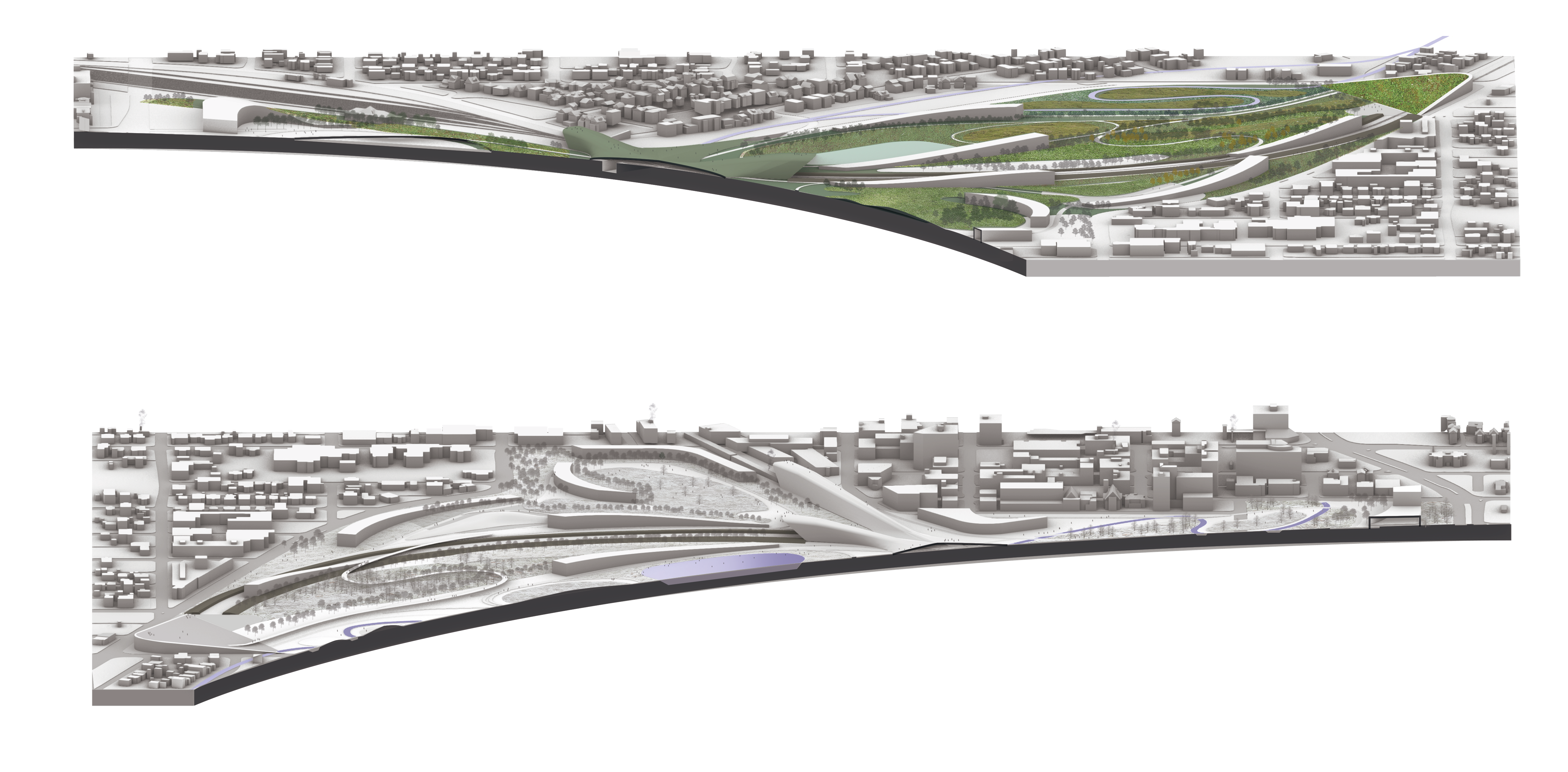
Arquitectónicamente, los edificios complementan el paisaje evocando imágenes tanto mecánicas como orgánicas, como los pétalos de las flores, las alas de las mariposas, pero también las trayectorias curvas de los rieles o los cuerpos sinuosos de los trenes. Sus formas también responden a su desempeño. Las topografías construidas, edificios-montaña y los macizos boscosos ayudan a mitigar el ruido de los trenes, los fríos vientos del norte durante el invierno y las escorrentías del sitio cuando llueve.
La propuesta mejora la calidad de vida de la comunidad proveyendo espacios cívicos y de recreo, incrementando la salud pública a través de la remediación del paisaje e instigando un sentido de comunidad a través de paisajes públicos, vibrantes y estimulantes justo en el corazón de la ciudad.
Program: Downtown redevelopment master plan
Site: Sudbury, Canada
Year: 2020
Status: Open international competition
Team: Daniel Daou, Priscila Gonzaga, Abraham Zarazúa, Víctor Pineda, Alejandra Ramos, Jaime Palacios
Greater Sudbury’s rich social and cultural life takes place at the confluence of geology, landscape, and infrastructure. The city’s modern history is linked to its geological past. Sudbury is located within the second largest known impact crater on Earth. This cosmic event is responsible for the region’s mineral wealth which was discovered as the country built its railway infrastructure. Sudbury’s founding is inextricably intertwined with the commercial interests to exploit its vast mineral reserves. Human activities have since completely altered the nature of its landscapes now defined by the tell-tale signs of extractive economies.
Since the eighties, Sudbury has made great strides to diversify its economy and remediate its surrounding environment–earning international recognition for its efforts. By 2050 the reclamation of Vale’s mining site could be well underway. Our proposal is a stepping stone between the newly recovered lands to the east and the Minnow lake conservation area to the west. We propose the recovery of Junction creek connecting the former extraction sites to the southwest to New Sudbury’s conservation area in the northeast through a riparian corridor.
The regional metabolism includes soil (tailings and biosolids), water (sewage, mineral polluted streams, watershed runoffs), vegetation (managed timber production and reforestation efforts), mineral (nickel and copper, but also platinum and palladium) and atmospheric exchanges (acid rain, noxious gasses, and mining emissions). In space, Sudbury can’t be understood without a cross section of the entire biosphere from the crust to the stratosphere, and, in time, from the Paleoproterozoic era 1.8 billion years ago and well into the Anthropocene, tens of thousands of years from now.
In this greater temporal and spatial scheme, our proposal fills the void at the center of an archipelago of green islands--like a spider perched on an emerald web. Sudbury’s new heart pumps a new transfusion of blue-green blood into this system, weaving together visual, historic, and cultural threads.
The infrastructural landscape of the mining operations could become a cultural heritage site. With its height of 380 meters, the superstack–the second tallest structure in Canada–dominates the landscape. It was built to disperse emissions higher up in the atmosphere and spare the surroundings from the effects of acid rain. The year of its completion, 1972, coincided with the First World Conference for the Human Environment in Stockholm, Sweden, which marks the global stage of the modern environmental movement. Much in the way that 1972 was also the year in which the “Blue Marble” photo shot from the vantage point of Low Earth Orbit changed our outlook on our environment, it is fitting that the monumental superstack acquires a new meaning by becoming a new public observation platform from which to gain a new perspective of Sudbury, its new center, its history, and landscape.
Inspired by the Living Building Challenge, our proposal aspires to exemplify “a city as beautiful as a forest.” The basic concept of the proposal is to merge the vacant and underutilized lands surrounding the train yards and Brady street. A star shaped structure with a minimal footprint bridges these gaps. The result is a continuous synthetic surface of 60 hectares extending from Lorne street to the west to Paris street to the east, and from Elm street to the north to Riverside drive and the train yards to the south. This surface contains three green “petals” or parks, each one leaning toward a specific program informed by its urban surroundings.
To the south, we have an ecological petal which represents a microcosm of Subury’s landscapes. It contains a densely forested area, a wild meadow, a wetland, and the riparian edge of Junction creek. This area works as an infrastructural landscape filtering any runoffs in its wetlands before returning them to the creek. It also features an open air stage and a performing arts center.
The north petal is dedicated to leisure and education. It features a proposed extension for McEwen School of Architecture, a library, student dorms, community gardens, and athletic fields.
To the west, the old downtown is revitalized by a set of key civic projects and the consolidation of all current parking lots and vacant lands into part of the park system. The southern half–The Junction–contains an arena, a congress center, and a hotel. The northern half contains the Place des Arts (connected to MSoA through a linear park), a vastly expanded Memorial Park–now criss-crossed by Junction creek–, and a renewed City Hall.
Architecturally, the buildings seek to complement the landscape by evoking both machinic and organic images of flower petals, butterfly wings, but also the curving trajectories and masses of trains and tunnels. Their aesthetics are also performative. Artificial topographies (which remind of the landscape’s own manmade features), landform buildings, and tree planting patterns, help mitigate the noise of the trains and the cold northern winds during winter and manage stormwater runoffs on site.
The proposal seeks to improve the quality of life of all members of the community mainly by (1) providing much needed civic and recreational spaces, (2) increasing public health through the remediation of the landscape, and (3) fostering a sense of community though vibrant and stimulating public landscapes right in the heart of town.